![](/images/other/stat-length.png)
![Tocht Stappen Le Castellard-Mélan - Boucle 3,7 km au départ de Fontbarliere par Manent et les Collons - Photo](https://media.geolcdn.com/t/1900/400/ext.pjpeg?maxdim=2&url=https%3A%2F%2Fmedia.geolcdn.com%2Ff%2F85e2e78c-2611-490f-8e52-193a05db09d4.jpg)
Boucle 3,7 km au départ de Fontbarliere par Manent et les Collons
jalien04
Gebruiker
![Lengte](/images/other/stat-length.png)
![Max. hoogte](https://static1.geolcdn.com/siteimages/upload/files/1508320355ic_sort_altitude_max_24dp.png)
![Positief hoogteverschil](https://static1.geolcdn.com/siteimages/upload/files/1508320355ic_sort_den_pos_24dp.png)
![Km-Effort](/images/other/stat-length.png)
![Min. hoogte](https://static1.geolcdn.com/siteimages/upload/files/1508320355ic_sort_altitude_min_24dp.png)
![Negatief hoogteverschil](https://static1.geolcdn.com/siteimages/upload/files/1508320355ic_sort_den_neg_24dp.png)
![Boucle](https://static1.geolcdn.com/siteimages/upload/files/16400158638029165_repeat_loop_refresh_sync_direction_icon.png)
![Stappen](https://static1.geolcdn.com/sitytour/trail-icons/101.png)
1h10
Moeilijkheid : Heel gemakkelijk
![Trail](https://static1.geolcdn.com/sitytour/trail-icons/104.png)
--
Moeilijkheid : Heel gemakkelijk
![Mountainbike](https://static1.geolcdn.com/sitytour/trail-icons/202.png)
25m
Moeilijkheid : Gemakkelijk
![Paardrijden](https://static1.geolcdn.com/sitytour/trail-icons/301.png)
48m
Moeilijkheid : Gemakkelijk
![Scan deze QR-code om de tocht te openen in de SityTrail-applicatie](https://capi.geolives.com/qq0zvz2zws4bq2lad0pu/sitytour/trails/2668244/qr.png?size=200)
Gratisgps-wandelapplicatie
Over ons
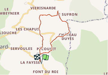
Tocht Stappen van 3,7 km beschikbaar op Provence-Alpes-Côte d'Azur, Alpes-de-Haute-Provence, Le Castellard-Mélan. Deze tocht wordt voorgesteld door jalien04.
Beschrijving
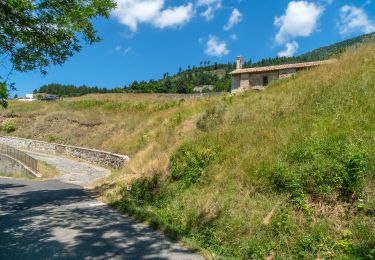
Départ Fontbarlière, route RD3, point kilométrique 19,700, entre Thoard à 4 km et le col de Fontbelle à 7 km.
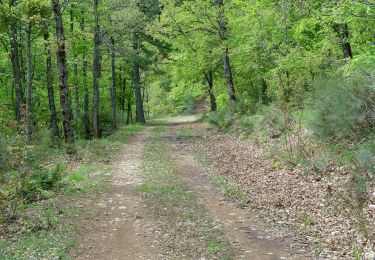
Avant de bifurquer sur la droite vers Château-Duyes et Manent, 500 m de route goudronnée RD3 montante, suivre ensuite deux panneaux Mélan à 1,5 km et à 2 km, en cours de montée à 2,3 km, au niveau d’un regard de contrôle du réseau d’eau sur le talus en face, prendre à gauche en descendant, longer le hameau des Colons, traverser la RD3 et emprunter le chemin public descendant (panneau) jusqu’à la borne incendie n°2, puis 200 m de RD3 vers l’aval pour rejoindre le point de départ.
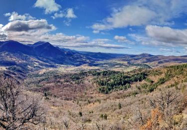
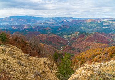
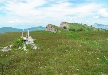
La vue est dégagée sur la majorité du parcours parmi des paturâges et des prairies avec vue sur la barre de Géruen, le massif du Blayeul et la vallée des Duyes.
Photos fléchées sur https://haut-pays-provencal.com/boucle-randonnee-37km-depart-fontbarliere
Plaatsbepaling
Opmerkingen
Wandeltochten in de omgeving
![Tocht Stappen Thoard - la Bigue par Thoard - Photo](https://media.geolcdn.com/t/375/260/ext.jpg?maxdim=2&url=https%3A%2F%2Fservices.sitytrail.com%2FGeolivesWS%2FDownloadMedia.ashx%3FTrailID%3D403749%26Media%3Dfix__20150404143536.jpg)
![Stappen Stappen](https://static1.geolcdn.com/sitytour/trail-icons/101.png)
Stappen
![](/images/other/stat-length.png)
![](https://static1.geolcdn.com/siteimages/upload/files/16400158638029165_repeat_loop_refresh_sync_direction_icon.png)
![Tocht Stappen Le Castellard-Mélan - Mélan Parua Taulisson Le Cognet Col de Mounis Mélan - Photo](https://media.geolcdn.com/t/375/260/ext.jpg?maxdim=2&url=https%3A%2F%2Fmedia.geolcdn.com%2Ff%2F225f8cb8-7a18-45e3-8799-a2543af22efb.jpg)
![Stappen Stappen](https://static1.geolcdn.com/sitytour/trail-icons/101.png)
Stappen
![](/images/other/stat-length.png)
![](https://static1.geolcdn.com/siteimages/upload/files/16400158638029165_repeat_loop_refresh_sync_direction_icon.png)
![Tocht Stappen Le Castellard-Mélan - Sentier des Brigants - Photo](https://media.geolcdn.com/t/375/260/ext.jpg?maxdim=2&url=https%3A%2F%2Fmedia.geolcdn.com%2Ff%2F68ab2d71-f8b9-4567-af4f-bab4b1fdbbaa.jpg)
![Stappen Stappen](https://static1.geolcdn.com/sitytour/trail-icons/101.png)
Stappen
![](/images/other/stat-length.png)
![](https://static1.geolcdn.com/siteimages/upload/files/16400158638029165_repeat_loop_refresh_sync_direction_icon.png)
![Tocht Stappen Le Castellard-Mélan - Boucle Fontbarlière (D3) La Tuilere-Vaumuse-Le Castellard - Photo](https://media.geolcdn.com/t/375/260/ext.jpg?maxdim=2&url=https%3A%2F%2Fmedia.geolcdn.com%2Ff%2Ff284b7fe-30f6-4088-9a24-ab410fc555dc.jpg)
![Stappen Stappen](https://static1.geolcdn.com/sitytour/trail-icons/101.png)
Stappen
![](/images/other/stat-length.png)
![](https://static1.geolcdn.com/siteimages/upload/files/16400158638029165_repeat_loop_refresh_sync_direction_icon.png)
![Tocht Stappen Le Castellard-Mélan - Auribeau depuis Melan - Photo](https://media.geolcdn.com/t/375/260/ext.jpg?maxdim=2&url=https%3A%2F%2Fmedia.geolcdn.com%2Ff%2Fe2744e9a-503d-47ec-88d4-b212681b0e6b.jpg)
![Stappen Stappen](https://static1.geolcdn.com/sitytour/trail-icons/101.png)
Stappen
![](/images/other/stat-length.png)
![](https://static1.geolcdn.com/siteimages/upload/files/16400158638029165_repeat_loop_refresh_sync_direction_icon.png)
![Tocht Stappen Le Castellard-Mélan - Grotte de st Vincent et Grande Aiguille au départ-arrivée le col de Fontbelle - Photo](https://media.geolcdn.com/t/375/260/ext.jpg?maxdim=2&url=https%3A%2F%2Fmedia.geolcdn.com%2Ff%2Fbd1c4004-bcbc-44ed-b324-f9e30e675275.JPG)
![Stappen Stappen](https://static1.geolcdn.com/sitytour/trail-icons/101.png)
Stappen
![](/images/other/stat-length.png)
![](https://static1.geolcdn.com/siteimages/upload/files/16400158638029165_repeat_loop_refresh_sync_direction_icon.png)
![Tocht Stappen Le Castellard-Mélan - Cretes du castellard et anciens chemins de Sisteron, col de Mounis, église et point de vue de depuis Mélan - Photo](https://media.geolcdn.com/t/375/260/ext.jpg?maxdim=2&url=https%3A%2F%2Fmedia.geolcdn.com%2Ff%2F9174a1af-1f24-49a2-8023-e0f070b5cc9d.jpg)
![Stappen Stappen](https://static1.geolcdn.com/sitytour/trail-icons/101.png)
Stappen
![](/images/other/stat-length.png)
![](https://static1.geolcdn.com/siteimages/upload/files/16400158638029165_repeat_loop_refresh_sync_direction_icon.png)
![Tocht Stappen Le Castellard-Mélan - Geruen au départ du col de Fontbelle - Photo](https://media.geolcdn.com/t/375/260/ext.jpg?maxdim=2&url=https%3A%2F%2Fmedia.geolcdn.com%2Ff%2Fb6b72807-9cda-421f-aadf-c3f6f0a4ac53.jpg)
![Stappen Stappen](https://static1.geolcdn.com/sitytour/trail-icons/101.png)
Stappen
![](/images/other/stat-length.png)
![](https://static1.geolcdn.com/siteimages/upload/files/16400158638029165_repeat_loop_refresh_sync_direction_icon.png)
![Tocht sport Le Castellard-Mélan - Crête de Géruen - Photo](https://media.geolcdn.com/t/375/260/ext.jpg?maxdim=2&url=https%3A%2F%2Fsecurestorage.geolives.com%2Fsitytour%2Ftrail-bg%2Fdefault.jpg)
sport
![](/images/other/stat-length.png)
![](https://static1.geolcdn.com/siteimages/upload/files/16400158638029165_repeat_loop_refresh_sync_direction_icon.png)